· today in space history · 11 min read
The Day the Navy's Eyes Reached Orbit
Forty-two years ago, an Atlas H rocket climbed into the California sky carrying four objects that would help the U.S. Navy track every Soviet warship on the planet - a mission so secret that even the satellites' true name wasn't declassified until 2023
On February 5, 1984, an Atlas H rocket lifted off from Space Launch Complex 3E at Vandenberg Air Force Base, carrying a payload that the Pentagon described only as “investigation of spaceflight techniques and technology.” This was, of course, a lie - the kind of carefully crafted non-explanation that characterized American military space operations throughout the Cold War.
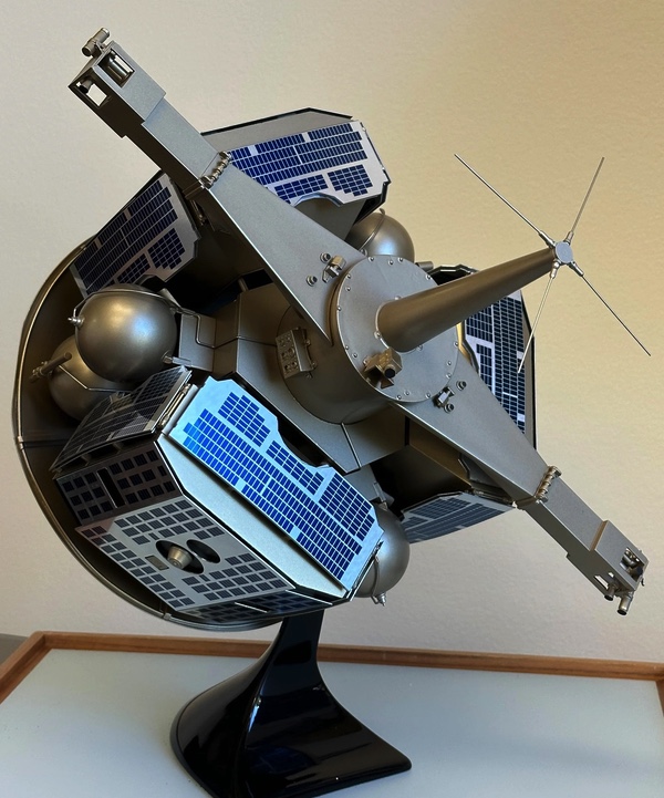
The rocket’s actual cargo was the seventh cluster of Naval Ocean Surveillance System satellites - designated NOSS 6 in unclassified catalogs (the numbering skipped the 1980 launch failure) and OPS 8737 in Air Force records. Within hours of launch, one primary spacecraft and three smaller subsatellites would separate and begin flying in formation approximately 1,100 kilometers above the Earth’s surface, their antennas pointed downward, listening for the electromagnetic whispers of every radar-equipped ship on the planet.
The system’s classified codename was PARCAE 7 (pronounced “par-say”). It wouldn’t be declassified for nearly four decades.
The Three Sisters
The name PARCAE wasn’t chosen randomly - and neither was the program’s unclassified designation, WHITE CLOUD, which the program manager selected because he’d been born in White Cloud, Kansas. But the classified name carried darker meaning. In Greek mythology, the Parcae were three sister goddesses - daughters of Zeus and Themis - who controlled the fate of every mortal. One sister spun the thread of life. The second measured its length. The third, Atropos (“she who cannot be turned”), cut the thread when a person’s time had come.
It was a grimly appropriate name for a trio of satellites designed to cut short the lives of Soviet warships.
The parallel to the satellite constellation was deliberate. A single NOSS satellite could detect radar emissions from ships at sea, but couldn’t precisely locate them - it could only spin the thread of information. Two satellites working together could narrow down a ship’s position through triangulation, but with some ambiguity - measuring the thread. Three satellites receiving the same signal could pinpoint a vessel’s exact coordinates using time-difference-of-arrival calculations - cutting the thread by providing targeting data for American weapons systems.
The NOSS satellites flew in a triangular formation, maintaining precise distances from one another through small onboard thrusters. Each spacecraft carried antennas designed to intercept radar transmissions across a range of frequencies - from navigation radars to fire control systems - and gravity gradient stabilization booms that kept those antennas perpetually pointed toward Earth. The technology had been developed for earlier ELINT satellites, and it came with quirks: occasionally a satellite would orient itself upside-down after deployment, its boom pointing earthward and antennas aimed uselessly at the stars. When this happened, ground controllers would retract the boom, wait for the satellite to tumble into the correct orientation, then redeploy it. When a Soviet destroyer switched on its radar anywhere in the world’s oceans, PARCAE was listening.
The Worst-Kept Secret in Space
For a program so classified that its true name remained hidden for 47 years, PARCAE had a remarkably public birth. Aviation Week & Space Technology - the aerospace trade publication that intelligence professionals half-jokingly called “Aviation Leak” - reported in August 1971 that the Navy was planning an ocean surveillance satellite. That was five years before the first launch.
The magazine stayed on the story. On May 10, 1976, it reported that a late April Atlas F launch from Vandenberg carried “the Navy’s first experimental ocean surveillance satellite,” built by the Naval Research Laboratory under the code name WHITE CLOUD. Two weeks later, the editors published a line drawing of the satellite itself. By July 1978, they had correctly identified that three satellites flew in each constellation, separated by approximately 43 kilometers.
The leaks didn’t stop the program, but they did create an odd situation: the existence of NOSS was an open secret among space watchers worldwide, while the PARCAE codename and detailed capabilities remained genuinely classified. Amateur satellite observers tracked the formations for decades, cataloging their orbital parameters with impressive precision. The NRO maintained the fiction anyway.
Why Satellites Beat Ships
The U.S. Navy had tracked enemy vessels before, of course. During World War II, radio direction-finding stations on shore could triangulate the position of German U-boats transmitting messages to their headquarters. But the Cold War presented a different problem: the Soviet Navy had grown from a coastal defense force into a genuine blue-water fleet, with submarines and surface combatants operating across the Atlantic, Pacific, and Indian Oceans.
By the early 1970s, the Soviet Fifth Eskadra in the Mediterranean alone could surge to nearly 100 vessels during a crisis - as it did during the 1973 Yom Kippur War. The Northern Fleet’s submarines prowled the Norwegian Sea and the GIUK Gap (the waters between Greenland, Iceland, and the United Kingdom), while Pacific Fleet units shadowed American carrier battle groups from the Sea of Japan to the approaches to Pearl Harbor.
Traditional surveillance methods couldn’t keep pace. Aircraft like the P-3 Orion could intercept ship emissions, but they had limited range, required tanker support for extended patrols, and couldn’t be everywhere at once. The underwater Sound Surveillance System (SOSUS) could track submarines in certain areas, but surface ships were a different problem entirely.
Satellites changed the equation. From 1,100 kilometers up, a constellation of NOSS spacecraft could monitor the entire ocean simultaneously, tracking every radar-emitting vessel 24 hours a day. The data flowed to CLASSIC WIZARD ground stations - at Adak in Alaska, Winter Harbor in Maine, Guam, Edzell in Scotland, and Diego Garcia in the Indian Ocean - then to a main downlink at Blossom Point, Maryland. From there it could reach fleet commanders worldwide.
From Pencils to Missiles
NOSS grew out of earlier Navy electronic intelligence programs with names like GRAB and POPPY - satellites that had been collecting signals intelligence since 1960. POPPY, which operated until 1977, had pioneered the time-difference-of-arrival technique that PARCAE would perfect. But processing POPPY data could take weeks - acceptable for mapping fixed radar installations, useless for tracking ships that might be hundreds of miles away by the time analysts finished their calculations.
The Naval Research Laboratory solved the processing problem, but the early years of PARCAE still produced more data than the Navy could use. Ed Mashman, a contracted engineer who worked on the program, later recalled the chaos: “Much of the data that had been coming in from CLASSIC WIZARD just went into the burn bag, because they could not keep up with the high volume.” In those days, the locations of potentially hostile ships were plotted on naval charts with pencils.
PARCAE 1 Launch
First operational NOSS constellation reaches orbit aboard Atlas F, proving the concept works.
PARCAE 4 Failure
An Atlas F suffers engine failure. The rocket pivots and explodes, destroying LIPS-1, the first Living Plume Shield communications payload.
Atlas H Debut
First NOSS launch using the purpose-built Atlas H rocket, carrying LIPS-2. The new vehicle will fly all remaining first-generation missions.
PARCAE 7 Launch
The seventh PARCAE cluster reaches orbit as NOSS 6, designated OPS 8737 in the unclassified catalog.
Final First-Generation Launch
PARCAE 9 and LIPS-3 complete the first-generation constellation. Second-generation satellites will require the much larger Titan IV.
Program Ends
The last PARCAE satellites cease operations after 32 years, replaced by a merged successor system.
PARCAE Declassified
The NRO finally acknowledges the program's existence at the Naval Research Laboratory's centennial celebration.
The breakthrough came in the 1980s with what the Navy called the “sensor-to-shooter” concept. Instead of satellite data flowing to regional reporting centers where analysts would compose messages for ships at sea, the information would go directly to shipboard weapons control systems. Captain Arthur Collier, the NRO program manager for PARCAE during this period, described the requirement in memorable terms: the “intercept-to-report” period had to be less than the time it took to fry an egg.
Making this work required new communications systems, new data formats, and new terminals aboard ships and aircraft. The Navy developed prototype receivers called Outlaw Shark, then integrated the capability into standard shipboard equipment. The Ships Emitter Locating Report “evolved from crude teletype printouts derived from raw intercept data to more user-friendly forms such as automatically displayed maps,” according to the official NRL history.
By the time PARCAE 7 launched in February 1984, the system was no longer just providing intelligence - it was providing targeting data that could guide missiles to their targets.
The Cold War at Sea
To understand why this mattered, you have to understand what the U.S. Navy was facing in 1984. The Soviet Navy had grown from a joke in the immediate postwar years to a genuine peer competitor. By the early 1980s, it operated over 560 combatants - more than twice the size of the U.S. fleet in raw numbers. Soviet Yankee-class ballistic missile submarines patrolled off both American coasts, their nuclear missiles within range of major cities. Delta and Typhoon-class boats could strike the continental United States from Soviet home waters.
The surface fleet was equally formidable. Kirov-class nuclear-powered battlecruisers carried batteries of long-range antiship missiles. Oscar-class submarines lugged 24 Granit cruise missiles each, specifically designed to kill American aircraft carriers. Soviet naval aviation could strike hundreds of miles into the ocean with Backfire bombers armed with supersonic missiles. By 1983, Soviet naval deployments outside home waters reached a record high of almost 60,000 ship-days.
The Reagan administration’s response was the Maritime Strategy - an aggressive posture that called for taking the fight to the Soviet Navy in its home waters rather than waiting for them to sortie into the Atlantic. Secretary of the Navy John Lehman declared in 1985 that American attack submarines would target Soviet ballistic missile submarines “in the first five minutes of the war.”
But you can’t attack what you can’t find. NOSS provided the foundation for the entire strategy by ensuring that the Navy always knew where Soviet surface combatants were operating. When a Kirov left Murmansk or a Slava-class cruiser departed Vladivostok, PARCAE satellites tracked the radar emissions that inevitably accompanied their movements. That information flowed through CLASSIC WIZARD to fleet commanders around the world - and increasingly, directly to the weapons systems that would engage those ships in a war.
The Quiet Legacy
The first-generation NOSS satellites were eventually replaced by larger, more capable “Improved PARCAE” systems launched on Titan IV rockets beginning in 1990. These second-generation spacecraft added the ability to intercept certain communications in addition to radar emissions, with the data processed and reported by the National Security Agency. A 1993 Titan IV failure destroyed an Improved PARCAE constellation worth over $800 million - a loss that particularly irritated members of Congress who had just cut $700 million from the intelligence budget.
The last PARCAE satellites were launched in 1996 and operated until 2008, when they were replaced by a merged successor combining ocean surveillance and electronic intelligence missions. The new system operates in pairs rather than trios - presumably because improvements in technology allowed two satellites to do what three once required. SpaceX launched a pair of these satellites in April 2022, marking the first time the Navy’s ocean surveillance constellation flew on a Falcon 9.
The PARCAE name remained classified until September 28, 2023, when the National Reconnaissance Office finally acknowledged the program at a ceremony marking the Naval Research Laboratory’s centennial. The declassification came 47 years after the first launch and 39 years after PARCAE 7 reached orbit. By then, the Cold War adversary the satellites had been designed to track had been gone for three decades - though one of the Slava-class cruisers they’d watched, Moskva, would meet its end in the Black Sea in 2022, sunk by Ukrainian missiles.
The oceans remain contested. The People’s Liberation Army Navy now operates more ships than the U.S. Navy, and Chinese naval vessels routinely operate in waters far from China’s shores. Russian submarines have resumed patrols off American coasts. The descendants of PARCAE 7 are watching them all, their antennas pointed downward, listening for the faint electromagnetic whispers that betray a ship’s presence on the vast, dark sea.
The sisters are still measuring thread.
References(8)
- Fate is in the stars: the PARCAE ocean surveillance satellites - The Space Review (2025)
- Above the clouds: the White Cloud ocean surveillance satellites - The Space Review (2009)
- A Spy Satellite You've Never Heard of Helped Win the Cold War - IEEE Spectrum
- America's Ears in Space - National Reconnaissance Office
- From the Sea to the Stars: A Chronicle of the U.S. Navy's Space and Space-related Activities - Naval History and Heritage Command
- Soviet Naval Activity Outside Home Waters During 1983 - CIA CREST
- The Soviet Navy in 1984 - U.S. Naval Institute Proceedings
- NOSS Double and Triple Satellite Formations - SatObs

Theodore Kruczek