· today in space history · 11 min read
A Celebration of Earth Day | Photos of Home
For 56 years, April 22 has been the day the world stops to look at itself. Before that was possible, someone had to invent the view. This is the story of how we first saw Earth from the outside, from a crashed V-2 camera in the New Mexico desert to the Blue Marble that still hangs on classroom walls.

We’ve celebrated Earth Day for 56 years now. On April 22, people gather to mark our planet, its environment, and the fragile peace that depends on both. It is a secular holiday in the most literal sense: there is no older one, because for most of human history we had no way to see the thing we were celebrating. To understand Earth Day, you have to understand how we first saw Earth from the outside, because it was not until we did that we had any way of knowing what we were looking at.
This is the story of how that view was built, photograph by photograph, over the course of about thirty years.
Our First Look
We first saw Earth’s curvature in the 1930s, from a photograph taken by Captain Albert W. Stevens. From a distance of 72,395 feet (about 13.7 miles), he captured the division between the troposphere and the stratosphere. In 1935, the Explorer II balloon climbed another mile higher for a similar look. But none of these photographs were taken in space, and none covered the whole planet. Without ballistic missiles we could not cross the Kármán line at 62 miles. Scientists could infer Earth’s curvature from the images. They could not yet see Earth as an object.
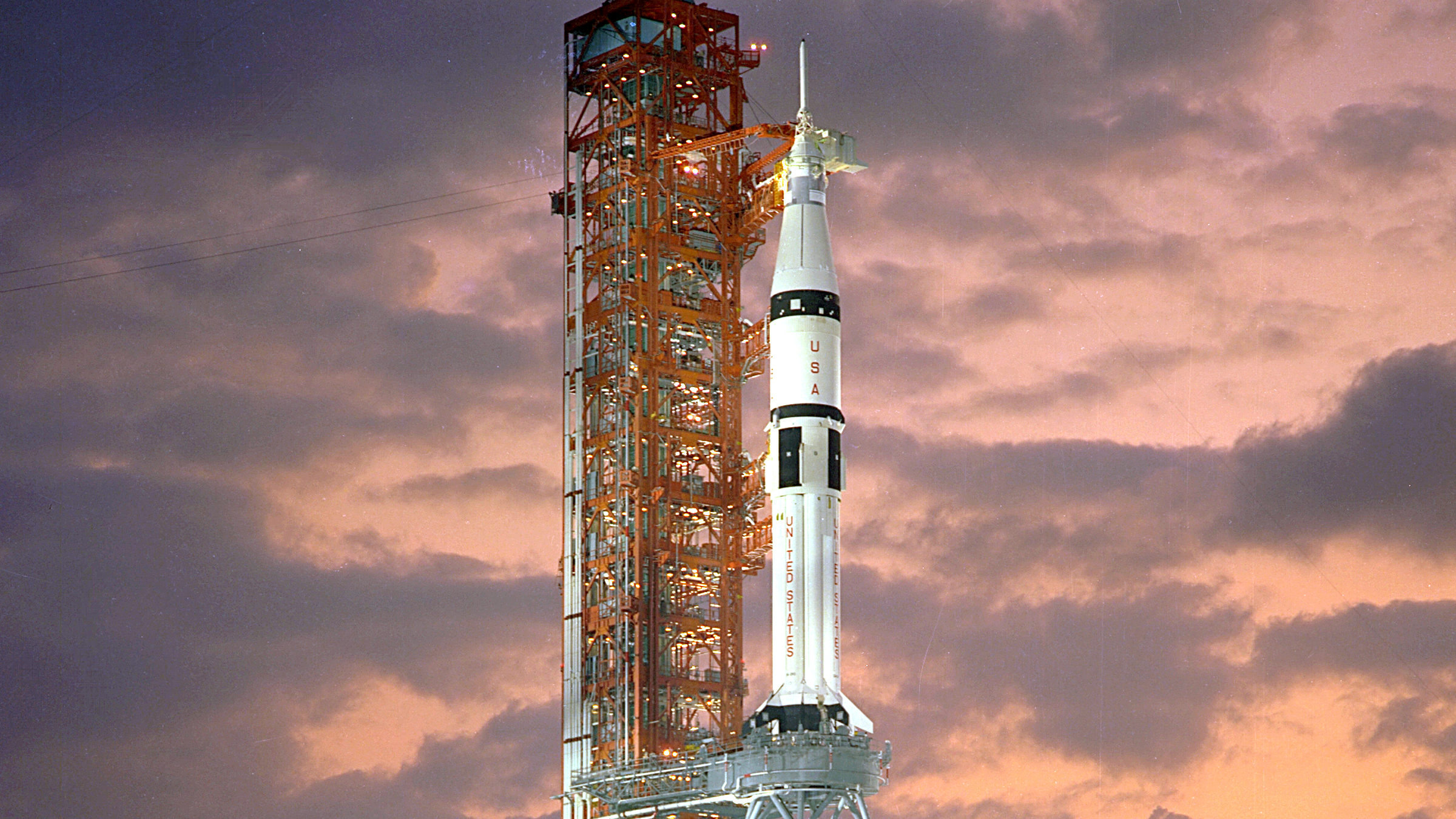
That changed in the 1940s. With the end of World War II, the United States inherited a sizable stockpile of V-2 ballistic missiles developed by Nazi Germany. At the White Sands Missile Range in New Mexico, the U.S. Army began firing them at the edge of space to study the upper atmosphere. Johns Hopkins Applied Physics Laboratory, U.S. Army research teams, and the Naval Research Laboratory used the captured rockets to measure cosmic rays, pressure, and temperature above the Kármán line.
Clyde Holliday, an American engineer working with the Army, attached a secondary experiment to one of those flights: a small 35 mm motion picture camera, rigged to photograph Earth from altitude. He designed a steel cassette inside the warhead section, heavy enough to survive the impact back to Earth at 500 feet per second.
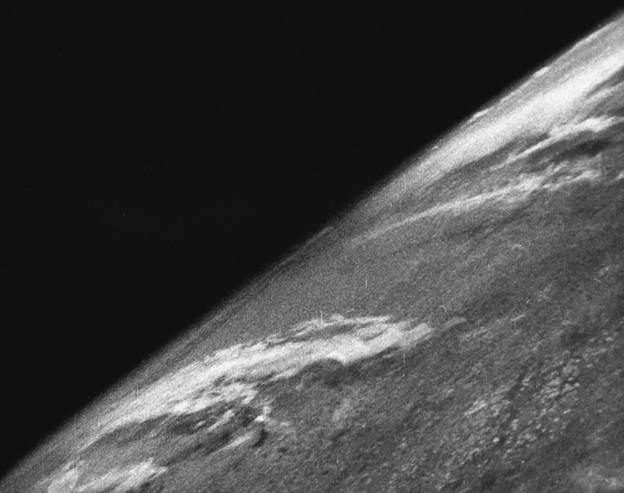
On October 24, 1946, V-2 No. 13 lifted off the White Sands pad with Holliday’s camera running one frame every second and a half. It climbed to 65 miles, well above the Kármán line, and gave us our first images of Earth from space. It was the eighth successful U.S. spaceflight.
Nineteen-year-old enlistee Fred Rulli was part of the recovery team. A camera came splintering down into the New Mexico desert at terminal velocity. Its outer shell was pulverized on impact, but the steel cassette inside survived intact. Back at the base, the film was developed and projected onto a screen. The men in the room, many of whom would later build America’s first satellites, shouted in delight at the grainy black-and-white frames showing a thin curve of horizon and a smear of cloud. It was the first time any human had seen what Earth looked like from outside itself, even if the vantage point was only sixty-five miles up and the subject was mostly the southwestern United States.
An Age of Space Photography
Space photography was never a primary scientific objective. It was easy enough to bolt a camera to a spacecraft that the images tended to be a side effect of missions built to measure something else. More rigorous photographic programs did follow later, studying weather, temperature, and geography from orbit, but the earliest images of Earth from orbit came almost as afterthoughts.
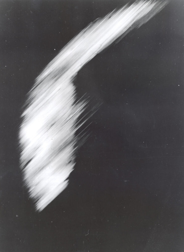
The first photograph of Earth from orbit came in 1959 from Explorer 6. The satellite was designed primarily to study radiation and micrometeorites, but it carried a simple scanning device intended to image cloud cover. The results were blurry. Most of Explorer 6’s power and data allocation went to its particle instruments, and a malfunction in one of its solar paddles left it operating at 63 percent capacity. What it did send back was still unprecedented: a coarse, low-resolution image of the Pacific Ocean seen from above.
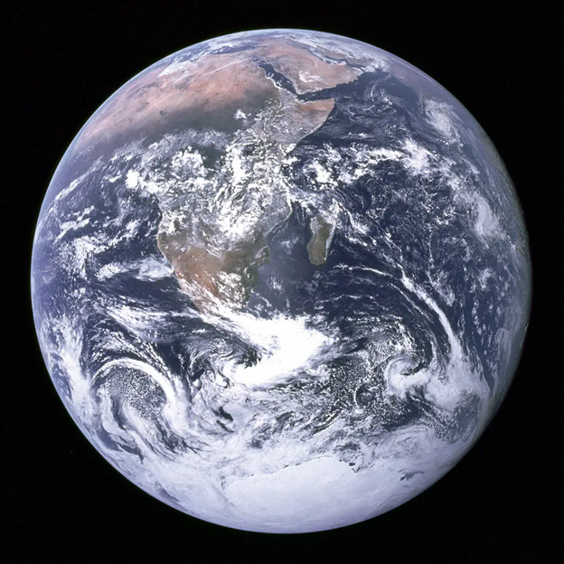
You may have noticed that the photographs so far show only a sliver of the planet, never the whole disk. The first full-disk image of Earth came in 1966 from Molniya-1 No. 3, a Soviet communications satellite in a high elliptical orbit. It was black and white, low resolution, and rarely seen in the West at the time. That same year, NASA’s ATS-1 captured the first full-disk photograph of Earth from geostationary orbit. It was also black and white.
Color came next, and the order of arrival is disputed in the margins. A satellite called DODGE (the Department of Defense Gravity Experiment) produced a color image of Earth shortly before ATS-3 did, but DODGE’s image was a technical curiosity on a classified program, and it is the ATS-3 image that tends to get cited as “the first” because it was public, widely reproduced, and built from a genuinely different technique.
ATS-3 was launched in November 1967 into geostationary orbit at an altitude of 22,300 miles. It carried the Multicolor Spin-Scan Cloud Camera, which did not take a photograph in the conventional sense. It scanned the three primary colors of visible light separately, transmitted each channel back to Earth, and reassembled the result on the ground into a composite image. Because the satellite was geostationary, it could stare at the same hemisphere continuously. Because it was three-axis stabilized, its images were sharp. On November 10, 1967, ATS-3 delivered a breathtaking color portrait of the western hemisphere, oceans and continents laid out in blue and brown and green against the black of space.
Our Grandiose Fragility
The next significant photograph had a more profound effect on humanity culturally than it did scientifically. In fact, it has been called, by wilderness photographer Galen Rowell among others, the most important environmental photograph ever taken. It also happens to be the reason Earth Day exists.
It started on Christmas Eve, 1968. Smoke rolled across Launch Complex 39 as Apollo 8 became the first crewed flight off the moonport. That was not the most significant thing Apollo 8 did. Three astronauts, Frank Borman, Jim Lovell, and Bill Anders, were about to become the first humans to orbit the Moon. About a billion people tuned in to a broadcast from the crew that evening, during which they read from the Book of Genesis and transmitted hazy photographs of the lunar surface.
Those are not the photographs in question.
During their ten lunar orbits, the crew methodically photographed the cratered surface beneath them, working a shot list prepared by NASA geologists. Bill Anders had a different muse. On the fourth orbit, as the spacecraft rounded the Moon’s eastern limb, Earth rose into the window. Anders pulled the Hasselblad away from Lovell, loaded a fresh magazine of color film, and took the picture that would come to be called Earthrise.
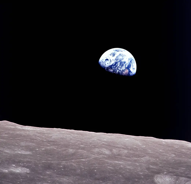
The simple cosmic moment resonated with people in a primal way. Earth, usually pictured as a vast expanse that served as the backdrop for humanity’s pursuits, was suddenly reduced to something tiny and fragile, emerging from the darkness of space above a dead lunar surface that looked, in that frame, larger than the world we were born on. People had spent a decade consumed by the Cold War, by rocket counts, by beating the Soviets to the Moon. Earthrise reminded them, in the span of a single exposure, what the context of all of that was.
The contrast between the distressed Moon and the beautiful blue Earth was remarkable. Earth was the only thing in the entire universe that had any colour.
The image spread across journalism and scientific communities almost immediately. It appeared on the cover of the Spring 1969 Whole Earth Catalog. It was later included in Life magazine’s book 100 Photographs That Changed the World. The crater directly beneath it in the frame was eventually named “Anders’ Earthrise” in his honor.
Earthrise quickly became the visual shorthand for a new kind of environmental movement. Earlier conservation campaigns had focused on specific harms: smog in Los Angeles, oil slicks off Santa Barbara, rivers that caught fire. Earthrise made it possible to campaign for something else, a unified planet as a single connected system. Sixteen months after Apollo 8, on April 22, 1970, twenty million Americans poured out onto the streets for the first Earth Day. The image was on posters, educational pamphlets, and nightly news coverage. It was not a metaphor. It was a photograph.
Certainly, Earthrise raised the level of ecoconsciousness that had been stirring for almost a decade. But beyond this new consciousness, Earthrise instilled a sense of urgency for those who were already on the front lines battling pollution and making the case that our health and planet were in danger.
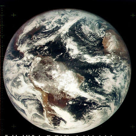
The Blue Marble
To close, we have to pay tribute to the most famous photograph of Earth ever taken. On December 7, 1972, about five hours into their translunar flight, the crew of Apollo 17 aimed a 70 mm Hasselblad with an 80 mm lens at the planet behind them and produced a single image that has been reproduced more times than any other photograph in history.
The shot is uniquely well-lit. Because the spacecraft was on a direct trajectory toward the Moon with the Sun almost exactly behind it, the crew saw a fully illuminated Earth at a distance of about 28,000 miles. Africa sits at the center of the frame. The Mediterranean peeks out at the top. A cyclone swirls through the Indian Ocean to the east. For the first time in a widely circulated photograph, the south polar ice cap is visible, because this was the first time a crewed spacecraft had been in the right geometry to illuminate it.
NASA’s official caption credits the photograph to the crew as a whole, because the three astronauts on board never conclusively agreed on who pressed the shutter. Harrison Schmitt, the geologist, has the strongest claim. What matters is that there is no border, no horizon line, and no context in the image except the planet itself. Earth is a ball. It is alone in the frame. It is the whole subject.
Why These Pictures Still Matter
It is tempting to treat the history of Earth photography as a technical progression, from V-2 camera to Explorer 6 to ATS-3 to Apollo. That is accurate, but it misses what the photographs actually did. Before October 1946, no human had ever seen Earth from outside itself. Before December 1968, no human had ever seen Earth from another body. Before December 1972, no photograph of a fully illuminated, borderless planet had ever circulated at scale. Each of those images rearranged something about how people thought of the place they lived.
The first Earth Day, sixteen months after Earthrise, was not a coincidence. The modern environmental movement is almost exactly as old as the first wide circulation of that photograph, and the overlap is not metaphorical. The people who organized it were holding up a picture, and the picture did most of the argumentative work on its own.
Fifty-six years later, Earth photography is routine. There are now dozens of Earth-observation constellations imaging the planet every few hours in resolutions the Apollo crews would have found absurd. We can watch wildfires advance in near real time. We can count cars in parking lots from orbit. We can measure methane plumes, count icebergs, and audit deforestation. None of that capability is what people think about when they hear “Earth Day.”
What they think about, if they think about any specific image, is still a grainy frame from 1968 or a saturated disk from 1972. The photographs that built Earth Day are still the photographs that define it. The rest of the satellite catalog, in all its planetary-scale sophistication, is in some sense the cost of being the species that took those two pictures and could not look away from them.
The full collection of NASA’s Apollo-era Earth imagery, including the uncompressed original scans of Earthrise and the Blue Marble, is preserved by the NASA Johnson Space Center and the Lunar and Planetary Institute. Most of it is in the public domain and freely available.
References(10)
- BBC World Service, Witness History — Apollo 8, Earthrise: The first colour photo of Earth from the Moon (interview with Frank Borman)
- Holliday, C. — Seeing the Earth from 80 Miles Up, National Geographic, October 1950
- NASA History Division — V-2 No. 13 and the first pictures of Earth from space
- NASA — Explorer 6: America's First Picture of Earth From Orbit, August 1959
- Suomi, V. — The ATS-3 Multicolor Spin-Scan Cloud Camera, University of Wisconsin-Madison Space Science and Engineering Center
- Apollo 8 Flight Journal — Earthrise sequence, NASA History Office
- Galen Rowell — Mountain Light: In Search of the Dynamic Landscape, Sierra Club Books, 1986
- Poole, R. — Earthrise: How Man First Saw the Earth, Yale University Press, 2008
- Earth Day Network — History of Earth Day
- NASA Johnson Space Center — Apollo 17 image AS17-148-22727 (The Blue Marble)

Mariana Mokhova