· deep dive · 11 min read
Lemu Nge
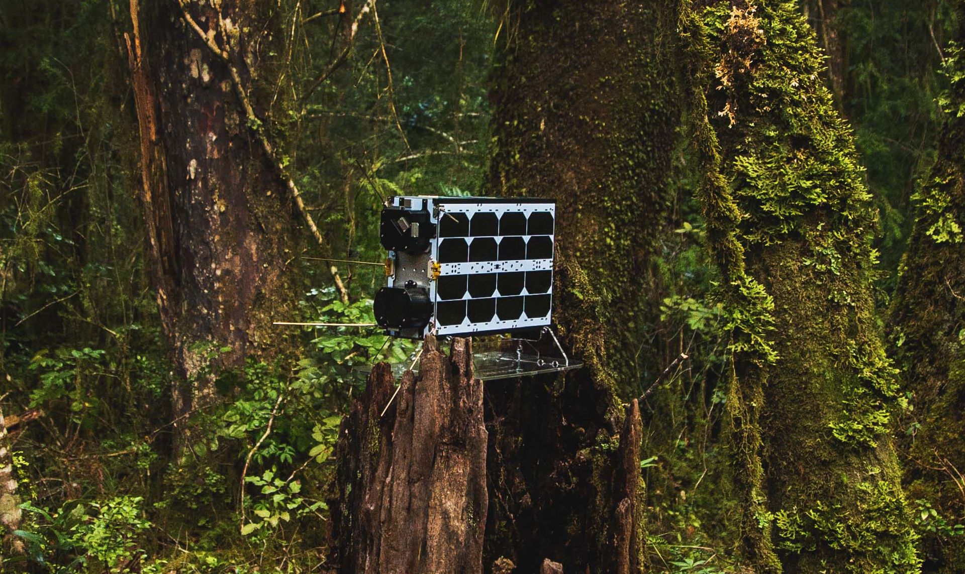
A shoebox-sized satellite designed in Chilean Patagonia is doing something no spacecraft has done before - hunting for biodiversity from orbit. Meet the Forest Eye.
There are roughly 10,000 active satellites in orbit right now. Thousands handle communications. Hundreds take pictures of Earth. A handful monitor weather, track ships, or sniff out methane leaks. Exactly one was built to look for life.
Lemu Nge - pronounced “LEH-moo NGE” and meaning “Forest Eye” in Mapudungun, the language of Chile’s indigenous Mapuche people - is a 6U nanosatellite about the size of a shoebox. It was designed in the lakeside town of Frutillar in Chilean Patagonia, assembled by NanoAvionics in Lithuania, equipped with a South African camera and Austrian ion thruster, and launched aboard a SpaceX Falcon 9 from Vandenberg Space Force Base on August 16, 2024. It’s the first private satellite in Chile’s history. It’s also the first satellite in anyone’s history built specifically to monitor Earth’s biodiversity.
That second distinction is the one that matters. We’ve been photographing Earth from space for over sixty years, but almost none of those observations were designed to distinguish between a eucalyptus plantation and old-growth native forest, or to detect when a wetland ecosystem is quietly degrading beneath what looks - to a regular camera - like perfectly healthy green. Lemu Nge was purpose-built for exactly that kind of detection, and in its first year of operations it’s already delivering results that validate the concept.
The satellite is operated by Lemu, a Chilean nature technology company founded by Leo Prieto - a serial tech entrepreneur who went from building Latin America’s largest Spanish-language tech blog to tracking biodiversity from orbit. The company’s pitch is straightforward: you can’t protect what you can’t measure, and right now, we’re spectacularly bad at measuring nature.
LEMU NGE
activeThe Nature Data Gap
Here’s a number that should bother anyone who thinks about environmental policy: the global economy depends on an estimated $44 trillion of annual economic value generation that’s directly dependent on nature and its services - pollination, clean water, carbon sequestration, soil fertility, flood regulation. That’s more than half of global GDP. Yet the data we have on the actual state of that natural infrastructure is astonishingly thin.
Most biodiversity monitoring still happens the old-fashioned way - researchers physically walking through forests, counting species, taking samples. This approach is thorough for the handful of sites that get studied, but the planet has roughly 51 billion hectares of surface area, and the places richest in biodiversity tend to be the hardest to reach. Tropical rainforests, high Andean wetlands, remote Pacific coastlines - precisely the ecosystems that matter most are the ones we know least about.
Satellite imagery helps, but traditional Earth observation satellites have a resolution problem when it comes to biology. The Landsat and Sentinel series, which form the backbone of public Earth observation data, capture images in a handful of broad spectral bands. They’re excellent for tracking deforestation at scale - you can easily tell the difference between forest and not-forest. But they struggle to distinguish between different types of forest, or to detect the subtle spectral signatures that differentiate healthy old-growth ecosystems from degraded ones that happen to still look green from above.
This is where hyperspectral imaging changes the game.
A Camera That Sees What Eyes Can’t
Lemu Nge’s primary payload is a hyperspectral camera built by Simera Sense, a South African company that’s carved out a niche building high-performance imaging systems for nanosatellites. The camera captures 32 spectral bands across a wavelength range of 450 to 900 nanometers - from deep blue through visible light and into the near-infrared, well beyond what human eyes can see.
The ground sampling distance (the area each pixel represents) is 4.75 meters from the satellite’s operational altitude of roughly 525 kilometers. That’s not the highest spatial resolution in the Earth observation business - commercial providers like Maxar can get down to 30 centimeters - but for biodiversity monitoring, it hits a practical sweet spot. You don’t need to count individual leaves. You need to characterize what kinds of vegetation cover a region, how healthy it is, and how it’s changing over time. At 4.75 meters per pixel, you can do that across entire landscapes while maintaining enough detail to distinguish between vegetation communities.
The real power isn’t in any single image - it’s in what happens when you stack 32 bands of spectral data and let trained algorithms parse the result. Every plant species has a slightly different spectral signature, a unique pattern of how it reflects and absorbs light across different wavelengths. Chlorophyll absorbs strongly in the red and blue bands but reflects green (which is why plants look green to us). But different species have different concentrations of pigments, different leaf structures, different water content - and all of these show up as variations in the spectral signature. A eucalyptus plantation and native Chilean temperate rainforest might look similar in a standard RGB photograph. In 32-band hyperspectral data, they’re starkly different.
Lemu Nge’s revisit time - how often it can image the same location - ranges from three to seven days, depending on latitude. The data is downlinked through high-bandwidth ground station antennas in Svalbard, Norway and Punta Arenas, Chile - essentially two ends of the Earth, which makes sense for a satellite in a sun-synchronous polar orbit.
Built Across Four Continents
One of the more striking things about Lemu Nge is the supply chain. This is a satellite conceived in Patagonia, designed by a team in Frutillar (population: roughly 17,000, known primarily for its German colonial architecture and lakefront views of the Osorno volcano), assembled in Vilnius by NanoAvionics, fitted with a camera from Stellenbosch and an ion drive from Vienna, and launched from California.
NanoAvionics provided the M6P satellite bus - their 6U platform that handles all the housekeeping functions: power generation and distribution, attitude control, communications, onboard computing, and thermal management. It’s a proven platform that’s flown on dozens of missions across everything from IoT communications to technology demonstrations.
The propulsion system, supplied by Austrian company Enpulsion, is a field-emission electric propulsion (FEEP) thruster that uses liquid metal ions as propellant. It’s a clever technology for nanosatellites - no pressurized tanks, no toxic chemicals, and precise enough thrust for both orbital adjustments and controlled end-of-life deorbiting. That last point matters. Lemu Nge was designed from the start to leave no debris behind when its mission ends. The satellite will use its thruster to lower its orbit until atmospheric drag takes over, and the spacecraft will burn up completely on reentry.
The SpaceX Transporter-11 rideshare mission that carried Lemu Nge to orbit was a typically crowded affair - dozens of small satellites sharing a Falcon 9 for a fraction of what a dedicated launch would cost. For a startup launching its first satellite, the rideshare model was the only economics that made sense. Lemu Nge separated from its deployer into a sun-synchronous orbit (SSO), meaning it crosses the equator at the same local solar time on every pass. This is standard for Earth observation satellites - consistent lighting conditions make comparing images taken days or weeks apart much more meaningful.
From Frutillar to Orbit
The journey from concept to launch took about seven years, which is actually quite fast for a space mission designed from scratch by a company that had never built a satellite before. Lemu was founded in 2020 by Leo Prieto, though the roots go deeper. Prieto’s career arc is an unusual one - he built ImageMaker, one of Latin America’s first major web agencies, at age 15, then founded FayerWayer (a Spanish-language tech blog that became the region’s most read), co-founded media company Betazeta, and eventually decamped to Patagonia to focus on environmental technology.
Lemu was announced at COP26 in Glasgow in November 2021, where Prieto presented the concept on the Blue Zone main stage. The NanoAvionics contract for the satellite bus was signed around the same time. The original plan called for launch in 2023, but like most space missions, the timeline slipped - the satellite didn’t reach orbit until August 2024.
The launch and early orbit phase (LEOP) validated all the onboard systems, followed by months of calibration work with partners including VITO (Belgium’s Flemish Institute for Technological Research) and ground truth stations coordinated through CEOS, the Committee on Earth Observation Satellites. Space threw the expected curveballs - temperature extremes, radiation exposure, and the occasional solar storm that temporarily disrupted communications. By mid-2025, Lemu was releasing its first validated hyperspectral scenes, and in November 2025, the satellite completed its first commercial customer tasking for Codelco, the world’s largest copper mining company.
COP26 Announcement
Lemu and Lemu Nge satellite mission announced at COP26 in Glasgow; NanoAvionics bus contract signed
Assembly Complete
Final integration and testing completed at NanoAvionics facility in Vilnius, Lithuania
Launch
SpaceX Transporter-11 rideshare mission lifts off from Vandenberg SFB carrying Lemu Nge to sun-synchronous orbit
First Validated Images
Initial calibrated hyperspectral scenes released, including captures of Chile's Biobío River and India's Krishna River regions
First Commercial Tasking
Successful customer imaging of Codelco's El Teniente mining division, delivered in under four days
What It’s Actually Seeing
The validated imagery released so far offers a preview of what purpose-built biodiversity observation can do. The initial calibration scenes - captured in April 2025 across multiple continents - include some genuinely useful demonstrations.
Along Chile’s Biobío River, the hyperspectral data revealed contrasts between sustainable forestry operations and stands of Chile’s most endangered native tree species that would have been invisible to conventional imaging. In the Caquena region of northern Chile’s Parinacota province, the satellite identified critical high-altitude Andean wetlands in an extremely climate-sensitive ecosystem that’s nearly impossible to monitor from the ground. And along India’s Krishna River in Telangana, the imagery mapped vegetation health in one of South Asia’s most intensively farmed and polluted river basins.
The first commercial work with Codelco is particularly telling. Mining companies are under growing regulatory pressure to demonstrate that their operations aren’t degrading surrounding ecosystems - and to prove it with data, not promises. Lemu’s six-month pilot with Codelco used Lemu Nge imagery alongside ground-based data to map ecosystems around the El Teniente and Ventanas operations, feeding into the company’s nature-positive strategy. This is the kind of bread-and-butter work that turns a cool science mission into a sustainable business.
Lemu has also signed a strategic partnership with Wyvern, a Canadian company operating its own hyperspectral constellation called Dragonette. The arrangement has Lemu purchasing Wyvern imagery to supplement its own data, while Wyvern can task Lemu Nge when the satellite has excess imaging capacity. It’s a pragmatic collaboration - one satellite can only cover so much ground, and the demand for hyperspectral data far exceeds what any single operator can supply.
Why It Shows Up in KeepTrack
Lemu Nge isn’t the kind of satellite that dominates the catalog. It’s a 6U CubeSat in a sun-synchronous orbit - one of thousands of small objects circling the planet at roughly 525 kilometers. But it stands out in KeepTrack’s visualization for a couple of reasons.
First, it has a name that catches the eye. Most objects in the satellite catalog are designated by their NORAD ID and a functional label. “LEMU-NGE” is unusual enough to make people click, wonder what it is, and end up reading about Chilean biodiversity startups at 2 AM. That’s a feature, not a bug.
Second, it’s a genuinely novel mission type. KeepTrack users tend to be people who are interested in what satellites actually do, not just where they are. The idea that a shoebox-sized spacecraft designed in Patagonia is orbiting overhead trying to identify tree species from 525 kilometers up is, frankly, the kind of thing that keeps space enthusiasts coming back. It’s a reminder that the satellite industry isn’t just about connectivity and surveillance - sometimes it’s about counting trees.
And third, there’s something appealing about the improbability of it. Chile isn’t exactly a traditional space power. Frutillar, population 17,000, is not JPL or ESTEC. The fact that a small team of environmental technologists managed to conceive, fund, build, launch, and operate a functional hyperspectral satellite from the shores of Lake Llanquihue says something about how accessible space has become. Twenty years ago, this mission would have been impossible for anyone outside a government agency. Today, it’s a startup with a SpaceX rideshare ticket and a Lithuanian satellite assembler.
Lemu Nge has a mission patch, too - a detail that shows someone on the team cares about the tradition. “Silvarum Oculus” reads the Latin motto, a nod to the Gemini-era convention of naming missions in Latin. It depicts the satellite watching over South America’s forests. Whether from space or from Frutillar, the view is the same - a planet with an extraordinary diversity of life, most of which we haven’t bothered to measure yet. One shoebox at a time, that’s starting to change.
References(10)
- Lemu Nge Satellite Overview - Lemu Official
- Chilean Startup Lemu Launched the First Satellite Dedicated to Biodiversity - GlobeNewsWire
- Lemu Nge Delivers On Promise - Biodiversity Signals from Space Now Visible - Lemu Blog
- The First Year of Lemu Nge - Lemu Blog
- NanoAvionics Signs Contract with Lemu for Biodiversity Mission - NanoAvionics
- Lemu Nge Technical Details - Gunter's Space Page
- Lemu Introduced at COP26 in Glasgow - Lemu Blog
- Wyvern and Lemu Collaboration Announcement - Wyvern
- Lemu Nge NORAD Tracking - Satcat
- Lemu Nge - SatNOGS Database

Theodore Kruczek